Listen to the article
Rising heat across continents
Across Europe, a persistent heat dome has brought record-breaking temperatures from Portugal to the Balkans. Portugal registered its hottest June day at 46.6°C, while Spain, France, and Italy faced similar extremes. Cities responded with emergency measures: school closures, restrictions on outdoor work, and wildfire alerts. Even typically cooler regions such as the UK exceeded 33°C, with hundreds of suspected heat-related deaths. In North America, New York, Toronto, and Washington, D.C. experienced highs of nearly 37°C, resulting in power outages and public transit disruptions. Meanwhile, northern India and Pakistan faced hazardous conditions as early as April, with temperatures reaching nearly 48°C. These trends confirm what climate models have long predicted: heatwaves are becoming more frequent, more intense, and arriving earlier each year. Urban planners and designers must therefore integrate thermal comfort assessment into every stage of design to improve liveability and resilience.
ENVI-met: modelling the urban microclimate
ENVI-met is a 3D microclimate simulation software that models the interaction between air, surfaces, vegetation, and buildings. The tool supports data-driven design and helps quantify the impact of planning choices on thermal comfort at street level.
ENVI-met allows professionals to:
- Simulate airflow and heat exchange across densely populated neighborhoods.
- Model heat absorption and radiation from urban materials.
- Visualize the cooling effect of trees, green roofs, and shading structures.
- Quantify thermal comfort indices, such as PET (Physiological Equivalent Temperature) and UTCI (Universal Thermal Climate Index).
These capabilities make ENVI-met a practical choice for municipalities, engineering consultancies, and urban developers seeking to assess the thermal performance of open spaces before construction.
Understanding PET: human-centred heat measurement
To understand how people actually experience heat in cities, air temperature alone is not enough. Physiological Equivalent Temperature (PET) provides a human-centred metric that translates complex meteorological data into a single value in °C.
PET integrates:
- Solar and long-wave radiation
- Air temperature and humidity
- Wind speed
- Human factors such as activity level and clothing
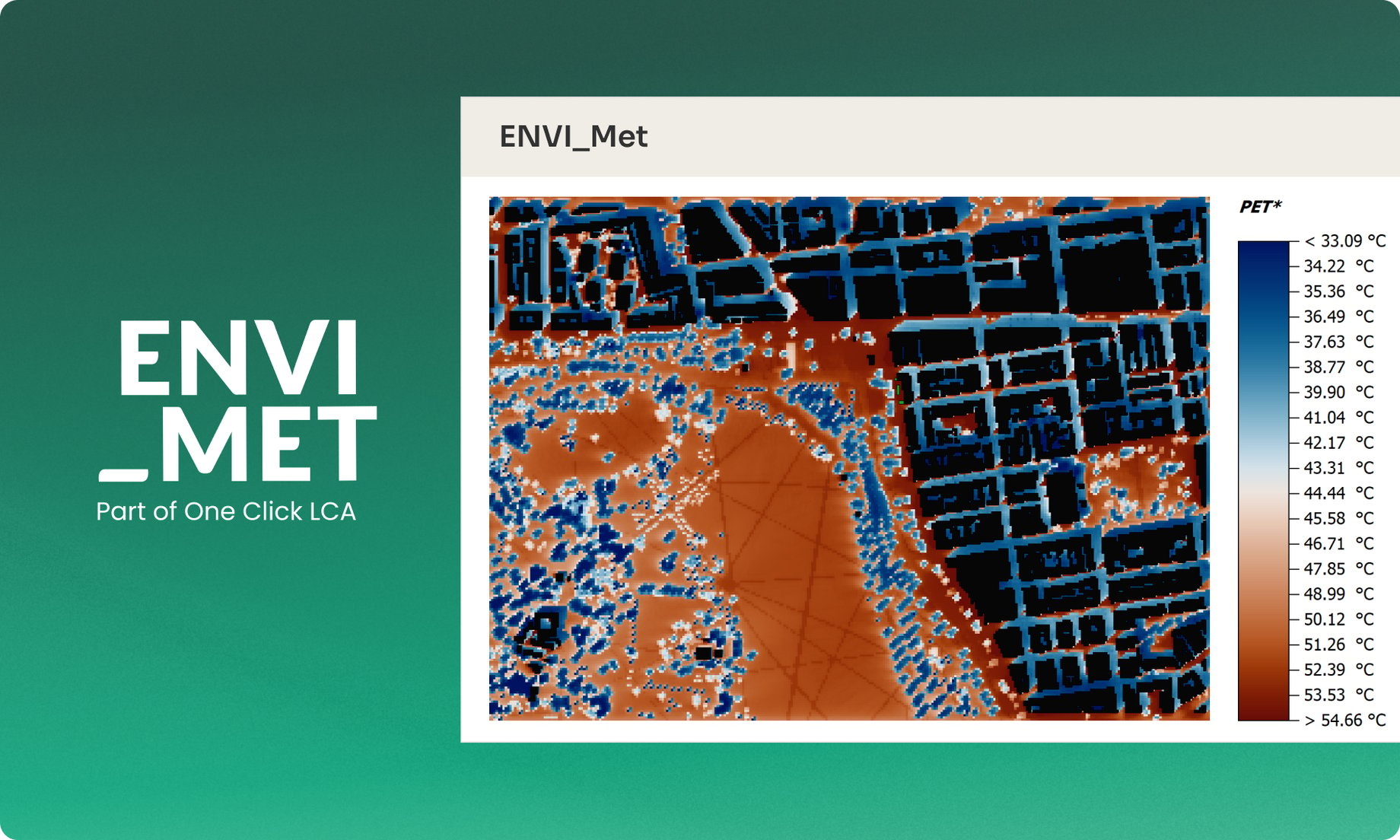
This combination provides a more accurate reflection of perceived thermal comfort, enabling planners to design spaces that effectively mitigate heat stress. For instance, a PET analysis of Hyde Park, London, at 2 PM during the summer reveals how tree canopy density and material reflectivity influence visitor comfort levels (Figure 1).
 Figure 1. Physiological Equivalent Temperature (PET) analysis of Hyde Park, London, at 2:00 PM during summer.
Applying ENVI-met and PET in urban design
Analyzing PET through ENVI-met enables professionals to:
- Identify heat-stress hotspots within new or existing developments.
- Test landscape and material alternatives before implementation.
- Demonstrate compliance with emerging thermal comfort regulations and green-building standards.
- Design more inclusive public spaces that ensure comfort for all users throughout the day.
In Madrid’s “Los Berrocales” development area, for example, 3D PET analysis with ENVI-met revealed how planting configuration and surface albedo directly influence pedestrian comfort (Figure 2). Such modelling guides design interventions that measurably reduce local air and surface temperatures.
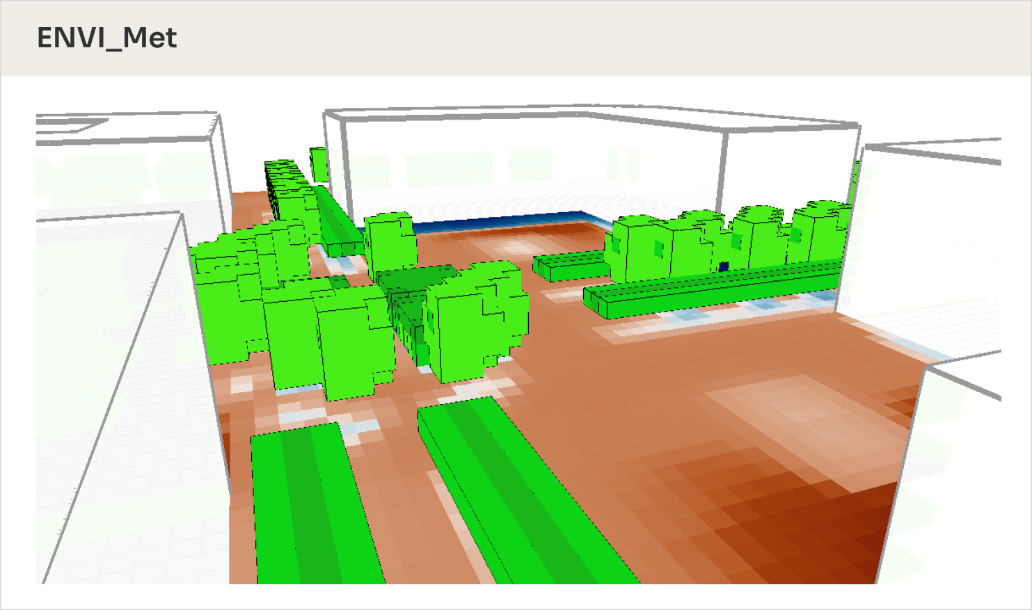
Figure 2. Three-dimensional Physiological Equivalent Temperature (PET) analysis of the Los Berrocales development area in Madrid, Spain.
Future-proofing urban environments
With dynamic pedestrian comfort modules and advanced radiation modeling, ENVI-met continues to evolve alongside the realities of urban climate change. Whether planning a city square, school campus, or residential quarter, these simulation tools provide actionable insights that help reduce heat exposure, improve outdoor usability, and strengthen long-term climate resilience.
Integrating data-driven tools like ENVI-met into urban design and policy frameworks enables planners to quantify, visualize, and mitigate heat risk, thereby creating cooler, healthier, and more sustainable cities.
Conclusion
As cities face intensifying heat stress and rapid urbanization, integrating thermal comfort assessment tools, such as ENVI-met and PET, into urban design is no longer optional; it is essential. These models enable planners and architects to visualize, quantify, and mitigate the effects of heat at the human scale, ensuring that public spaces remain livable and adaptive under changing climates. By embracing data-driven microclimate analysis, urban designers can make informed decisions that enhance comfort, promote health, and build resilience, creating cities that not only withstand rising temperatures but also thrive in them.
Frequently asked questions
1. What is ENVI-met, and how does it help urban planners?
ENVI-met is a 3D microclimate simulation software that models the interactions between air, surfaces, vegetation, and buildings. It helps urban planners visualize and quantify the effects of design choices, such as materials, greenery, and shading, on local temperatures and human thermal comfort. This allows cities to plan cooler, more resilient public spaces.
2. What does PET (Physiological Equivalent Temperature) measure?
PET measures how humans actually feel temperature by integrating air temperature, humidity, radiation, wind, and human factors such as clothing and activity. It provides a more accurate understanding of thermal comfort than air temperature alone, helping planners design spaces that reduce heat stress.
3. Why are ENVI-met and PET essential for urban design?
Together, ENVI-met and PET allow planners to model and analyze the microclimate at a human scale. This helps identify heat-stress hotspots, test cooling strategies like tree placement or reflective surfaces, and ensure outdoor spaces remain comfortable and usable as temperatures rise.
4. Can ENVI-met be used for existing developments?
Yes. ENVI-met can model both new and existing urban areas, helping planners retrofit spaces for better comfort and sustainability. Simulations can reveal where interventions, such as shade structures or vegetation, would have the most significant impact.
5. What are the main benefits of integrating ENVI-met and PET in city planning?
-
Identify heat hotspots early
-
Design inclusive, comfortable outdoor environments
-
Support data-backed sustainability policies
-
Comply with new climate adaptation and building standards
-
Improve citizen health and well-being