.jpg?width=1840&name=pexels-imad-clicks-18479149%20(1).jpg)
A Biodiversity Net Gain (BNG) assessment identifies and evaluates the potential impact that developments may have on the natural environment around them.
When is an early-stage BNG assessment required?
Following the mandate implemented in early 2024, it is now a legal requirement in England for major developments to produce an assessment of the impact of their construction on the natural environment, and evidence how they have improved it, as part of the planning process.
The National Planning Policy Framework (NPPF) emphasises the need for addressing BNG early in the development, factoring it into site selection and design options, as well as engaging with the relevant Local Planning Authority to discuss options and expectations.
When submitting a planning application subject to Biodiversity Net Gain, the application must include the biodiversity unit value of the site (the ‘baseline’). If planning is granted, a biodiversity gain plan with complete calculations of any created or enhanced habitats and final net change in biodiversity units must be submitted before projects begin. This is designed to establish and agree on the baseline value of the site and to encourage the submitted gain plan to be based on final designs. Between these two submissions, the process should be iterative as the development progresses.
Who is currently responsible for completing BNG assessments?
It has been standard industry practice for developers to utilise the services of an ecologist, who will survey a site by classifying and measuring the habitats present. Ecologists will also typically complete the condition assessment, which includes assessing the habitats on site against criteria that describe an ecologically optimum example of the same habitat. Not all habitats require a condition assessment, but it must be assigned to all habitats that require it in order to calculate biodiversity units.
Why is this a challenge moving forward?
Now that Biodiversity Net Gain impact reporting is a legal requirement for large developments in England, the need to produce and scale early-stage assessments easily and quickly is increasing, and the demand for ecologists will soon outweigh supply. As awareness of Biodiversity Net Gain becomes more widespread, different project stakeholders who are not biodiversity experts will need to be equipped with the data, tools, and knowledge of the steps required to complete assessments.
Step 1: Collecting the data for a BNG assessment
In order to complete a Biodiversity Net Gain calculation, data on habitats is required as a starting point. A habitat is a categorisation of an area based on characteristics, such as climate and plant species that are present. UK Habitat Classification (UKHab) is a free-to-use, comprehensive approach to classifying habitats, and One Click LCA has partnered with them in the development of the One Click LCA Biodiversity Net Gain (BNG) Tool. This means that anyone completing an assessment can align habitats within the tool to the statutory biodiversity metric.
For every habitat, users must assign a value to two core quality parameters that determine how many biodiversity units they can achieve:
- Habitat and condition
Condition is a measure of one instance of a habitat against an ecologically optimal example, to measure variation between areas of the same habitat type.
- Strategic significance
Strategic significance is a semi-qualitative parameter based on the local significance of a habitat, which may differ from the national scale significance of distinctiveness.
It is recommended by the Department for Environment, Food and Rural Affairs (Defra) that surveys and condition assessments are completed during the appropriate time of year for the habitats present on site. However, when completing early-stage assessments or scoping multiple potential sites, this may not be feasible.
Determining habitat and condition
For those completing assessments, third-party data is available that can inform early-stage inputs by providing high-level habitat classifications, for example:
- Natural England Living England Habitat Map
- UK Centre for Ecology & Hydrology (CEH) Land Cover Maps
- OS MasterMap Topography
This type of data requires Geographic Information Systems (GIS) software to view and measure, with the two most popular tools being QGIS and ArcMap.
These products are designed to be used at a higher resolution to inform land management practices or strategy, but can provide a reasonable estimate of habitat type at site level. When used in combination with services such as Google Earth and Google Street View, it may also be possible to get an estimation of condition, for example if the extent of a habitat has reduced over a short period of time on Google Earth or certain indicator species are visible on Google Street View.
A free web-based mapping tool provided by Defra, MagicMap, is invaluable at all stages of a Biodiversity Net Gain assessment, especially early on when estimating habitat types, condition, and strategic significance. Data layers of habitat type, soil type, and satellite imagery can be used to determine what habitats may be on site, whilst layers with protected sites, woodland schemes, and species-specific data can help determine strategic significance.
Determining strategic significance
There are two broad pathways to determining strategic significance:
- If your site is in an area with a published Local Nature Recovery Strategy (LNRS), this strategy should be used in your assessment.
- If an LNRS has not yet been published, the relevant planning authority for the area should specify which data and documents can be used.
Local Nature Recovery Strategies were introduced as regulations by the government in 2023. They are a system of landscape scale spatial strategies to map both existing areas of biodiversity areas as well as proposed areas designed for strategic interventions. This is the list of responsible authorities for each LNRS is provided by Defra.
If the site is covered by a LNRS, the criteria for determining strategic significance are straightforward. When the habitat parcel is located in a proposed intervention area and the intervention is consistent with the recommended intervention (for example, the same habitat type) then strategic significance is high. If these criteria aren’t met then strategic significance is low and medium should not be used.
In the absence of LNRS, the criteria for high strategic significance is similar if the relevant planning authority has specified a document or data source with location-specific recommendations. If this is not the case, medium strategic significance may be determined with a qualitative review of any available documents and data, with professional judgement and justification. For example, creating or enhancing a habitat type that is locally scarce, improving connectivity between green areas, or positive interventions in proximity to a designed site could all be considered grounds for medium strategic significance.
Examples of documents that may be used:
- Draft LNRS
- Local Plans and Neighbourhood Plans
- Biodiversity Action Plans
- Designed sites Management Plans
- Green Infrastructure Strategies
Exercising data caution
When estimating habitat type and condition, a precautionary approach is best. In the absence of evidence suggesting otherwise, assigning a higher condition score will likely alleviate negative surprises further into the project, and will also help inform the scale and type of post-development habitats required to achieve net gain. Similarly, preparing multiple versions of the same assessment using similar habitats may also save time in the future.
All habitats have a fixed value called “Distinctiveness" which represents the overall relative biodiversity value of that habitat, based on factors such as rarity and species richness. In winter, many habitats may look similar. A habitat could be estimated as one type with a distinctiveness value of 4, but in spring or summer is confirmed to be another type with a distinctiveness of 8, which would cause a significant increase in baseline units.
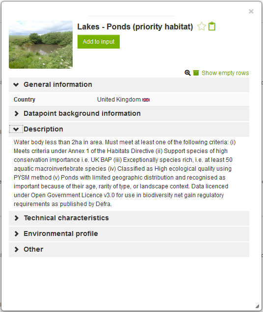
For example, creating two versions of the same site baseline with one containing ‘Other neutral grassland’ in ‘Good’ condition, and the other containing ‘Lowland meadows’ in ‘Moderate’ condition, if a survey is not currently feasible. Assuming both were 1 hectare (ha) in size and assigned a high strategic significance, the first version would have 13.8 habitat units, whilst the second would have 18.4.
This is due to the difference in distinctiveness, with ‘Lowland meadows’ having the highest value possible, so it is worth more despite the lower condition. If this 1ha of grassland is known to be impacted by the development, this already allows you to start considering suitable post-development interventions for both scenarios, should a survey happen in the future.
You have your data. Now how do you perform your BNG assessment?
Step 2: Calculating biodiversity units with One Click LCA
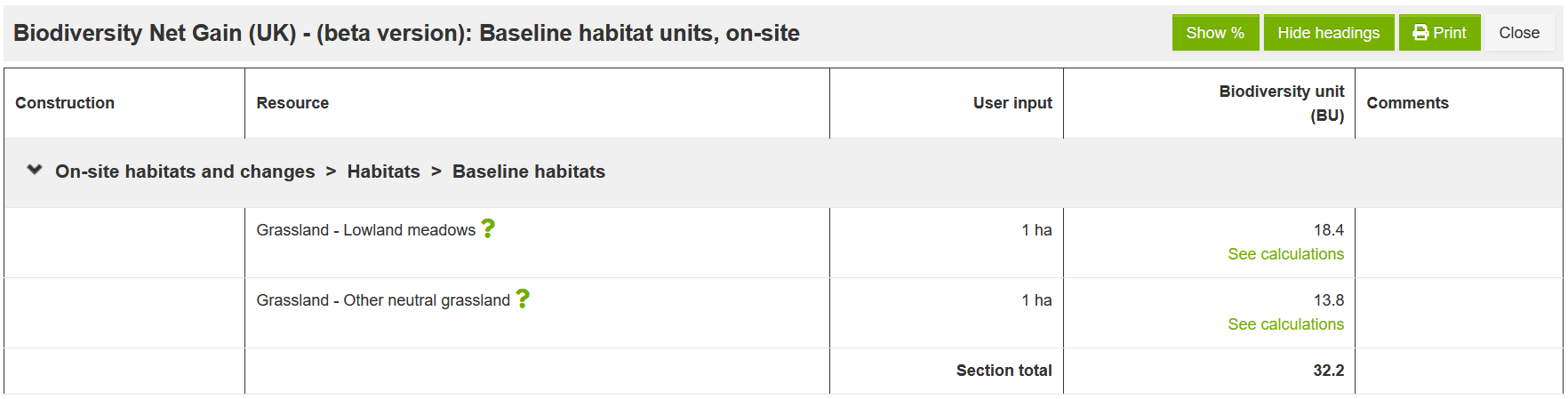
After collecting the required data, you can use One Click LCA’s Biodiversity Net Gain Tool to start calculating biodiversity units. Start by adding the pre-development site habitats to the baseline habitats question. For each habitat, input the size in hectares , the condition, and strategic significance. It is recommended to first add all baseline habitats before inputting values to the area retained or area enhanced options.
At this point, you can see your results — the total biodiversity units for the baseline of the site. This step of the process is a good time to prepare some other designs in the project and compare baselines of different sites, so that in the case of high or very highly distinct habitats, you will already see that significant creation or enhancement may be required.
In the example scenario below, the baseline shows a single 5 ha area of grassland, of which 1 ha (20%) was retained and 1 ha was enhanced. Retaining a habitat means that the post-development condition remains the same, which does not always mean that no action is needed. Ongoing management may be required to maintain the condition.
Assuming 2 ha of the total 5 ha were accounted for, 3 ha was lost during development, and that area is now available for creation of new habitats. The area may be divided into as many parcels as required, as long as the total balances. In this scenario, the 3 ha has been filled with a new building and associated sealed surfaces, a small green roof, and some shrub planting.
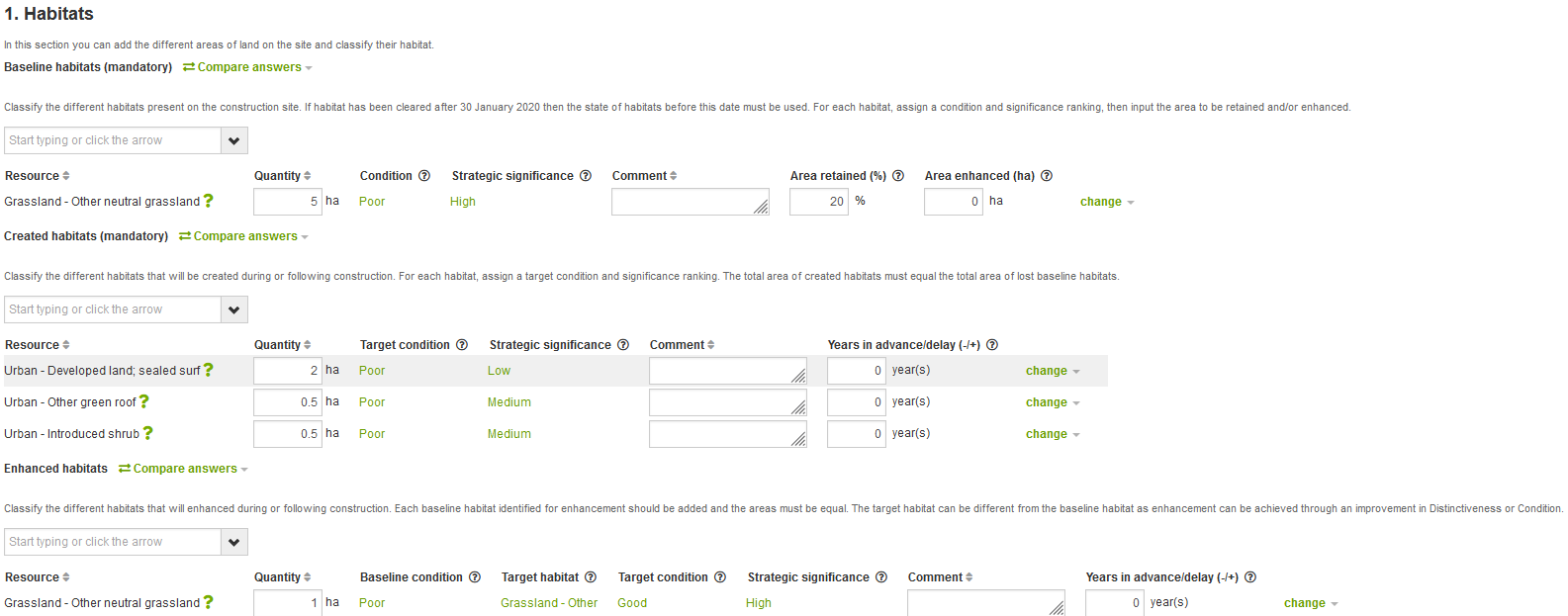
This process needs to be repeated for all habitats on-site and off-site, if required. Hedges and watercourses are optional in the tool but become mandatory if any of these features are present on the site.
Step 3: Understanding BNG assessment results
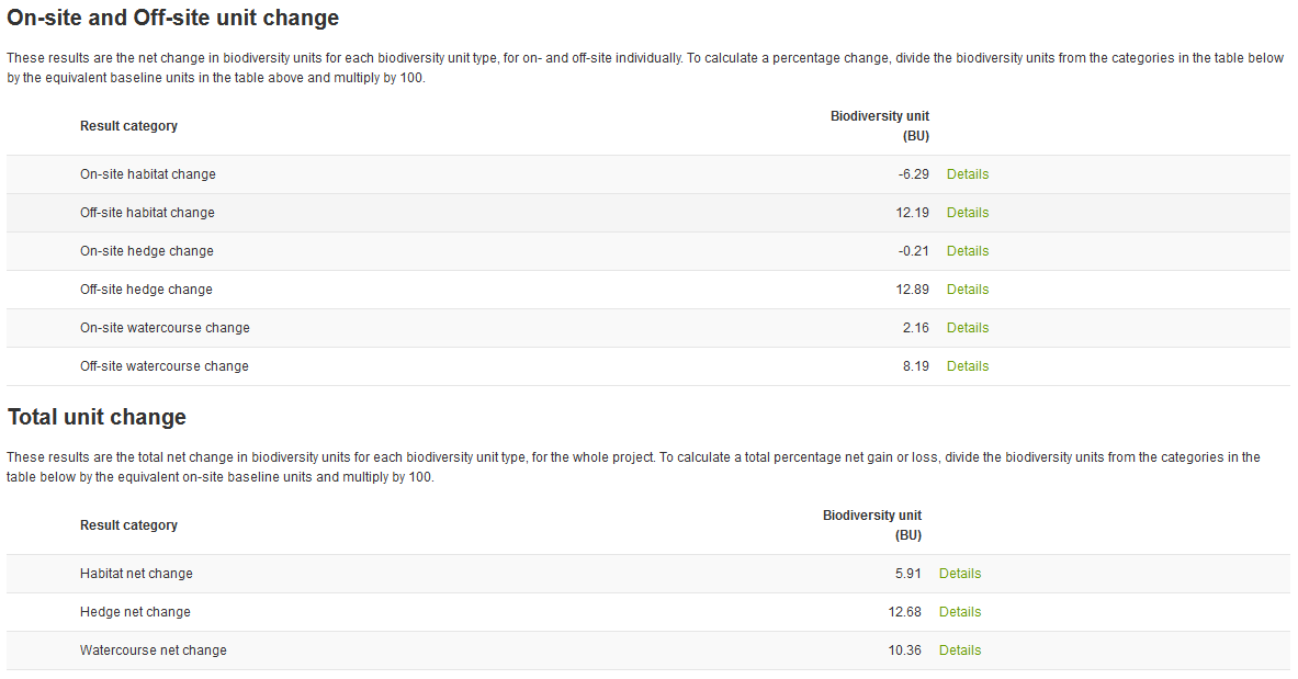
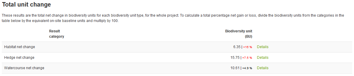
Once all the data for your site is added to the relevant sections, you can clearly view your results. Results are also presented in a breakdown by unit type, intervention, and site, which is useful to view the biodiversity units achieved by each habitat individually. However, the most important results show the net change in units for sites individually and as a total for the project.
Results are shown as the change in biodiversity units, as this is needed when completing a biodiversity gain plan. This can be converted to a percentage change similar to this example:
- To calculate a percentage change for a site individually, divide the unit change result by the equivalent baseline units and multiply by 100. In this example, the on-site habitat change is -6.29 and the baseline habitat units (not shown) are 23.0, so (-6.29 / 23) * 100 = -27.348 — a net loss of almost 30%
To calculate a percentage change for the total project, the net change result is divided by the sum of the equivalent on-site baseline units and multiplied by 100. In this example, the habitat net change is 5.91, and the on-site baseline habitat units for on-site are 23.0, so (5.91 / 23.0) * 100= 25.696%. This illustrates an example where off-site gains were required to achieve biodiversity net gain.
The tool also provides quick comparisons of designs, and each project can feature multiple designs. The example below shows a comparison of two scenarios. Both scenarios feature the same habitats for on- and off-site. The first design iteration added a 1 year delay to all off-site enhancements, while the second started off-site enhancements 1 year in advance. This small change resulted in more than 15% increase in habitat units, with smaller increases for hedges and watercourses.
BNG assessments with One Click LCA BNG Tool
Biodiversity Net Gain, and the legal mandate to report on the impact of developments on the natural environment around them, has an increasing impact on sustainability in construction. As more non-ecologists take on responsibility for measuring Biodiversity Net Gain as part of their projects, it is imperative that they have access to the right tools and data. One Click LCA’s Biodiversity Net Gain (BNG) Tool enables simple, accurate and scalable assessments.
Learn more
- Read Biodiversity Net Gain: UK leads way to better measurement of global construction biodiversity impact
- Decarbonization News: BREEAM V7 focused on increasing Biodiversity Net Gain (BNG) in developments across England